Westport in Brief!
EverythingWestport.com
Sunday, May 2, 2021
Quick
Article Index . . .
East Beach study to be revised.
|
East Beach study to be revised. Friday,
April 23, 2021
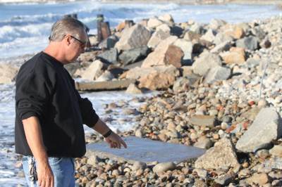
Above:
Resident Russell Plamondon points to the spot where his neighbor's trailer
used to be parked. Hurricane Irene swept everything away. Photo | EverythingWestport.com ©
2012 All rights reserved.
Special to
EverythingWestport.com Is
the road’s future headed for a total washout? Click
Here to read the article about Hurricane Irene’s willful destruction of
East Beach Road The East
Beach Corridor Vulnerability Study Committee recently reviewed the draft
report of a study assessing the neighborhood’s risks from the growing impacts
of climate change, and asked its consultants to revise the projections for how
much of a rise in sea levels the town can expect in the next few decades
before submitting the final report to local and state officials. East
Beach Road is an emergency exit route for residents living south of the Route
88 bridge, which if disabled, would trap those residents if a hurricane wiped
out the vulnerable East Beach Road. The town
contracted for the climate change vulnerability assessment by the Woods Hole
Group in order to develop short- and long-term plans for dealing with the
long list of issues related to the likelihood of a continuing rise in sea
levels and the increasing frequency and severity of major storms damaging
infrastructure and coastal properties. The study was funded by a state
Municipal Vulnerability Program (MVP) grant. The
final report will include the consultants’ recommendations for local planning
to elevate or otherwise protect East Beach Road from repeated storm washouts;
upgrade utility services in the area; develop better emergency access and
egress plans for the barrier beach area; and consider a dune nourishment
program to offset beach erosion. The
draft report recommendations included the immediate establishment of a town
climate resiliency committee to start the local planning process for dealing
with climate-related issues and funding those initiatives. It also suggested
the development of a long-term plan for the eventual “managed retreat and
relocation” of homes and residents from the East Beach Corridor when sea
levels get too high. The
draft also identified a number of sources of state and federal funds which
could be used to finance the town’s efforts to combat sea level rise and
related climate change issues. It also makes clear that state and federal
authorities will not allow “coastal armoring” of barrier beach areas with seawalls
or breakwaters that could protect roads, homes, or other resources. Much
of the debate at the April 21 study committee meeting focused on comments
provided by local reviewers of the draft report. Former selectman Michael
Sullivan submitted a multi-page commentary that challenged the state’s steep
projections for sea level rises in coming decades, as well as the data on
historic erosion trends for East Beach. For
example, the state projected the likely 20-year rise in sea level for the
period ending in 2030 would be one and a quarter feet, R. Michael Sullivan
noted, while the actual rise during the first decade was less than two
inches. Those state straight-line upward projected increases in water levels
used by consultants are just not realistic, based on actual local data, he
suggested.
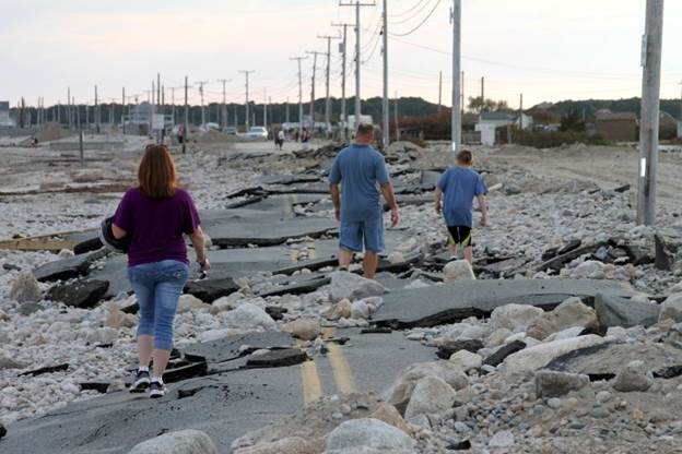
Above: Now What? 750 feet of East Beach Road looks like a
scene from an apocalyptic future. Completely destroyed by Irene's wrath, the
shattered road has thrown the town into a quandary as to what to do next. Photo | EverythingWestport.com ©
2012 All rights reserved. Click Here to read the article about
Hurricane Irene’s destruction of East Beach Road “I
don’t think we want to have a report that’s predicting a foot and a quarter
sea level
rise by 2030, and be halfway through that period and only seeing an inch and
a half rise,” R. Michael Sullivan said at the virtual meeting. “It takes away
our credibility,” and
creates doubt about the validity of the recommendations based on those
projections, he argued. Lead
modeler for the Woods Hole Group Nasser Brahim agreed that the state’s projections
for a highly probable 2.3-foot rise in sea levels by 2070 were a little
unlikely to occur, but the state was planning for worst case scenarios so as
not to be caught unprepared by accelerating conditions. Brahim
said he would revise the report’s charts to show the local data was much
lower than the projected rises, but noted that the state’s high projections
did not significantly impact the report’s recommendations for local actions
to be considered. Study
Committee Chair John Bullard said the report’s projections, ranging from
conservative estimates to worst case scenarios for water level rises were
endlessly debatable, but not the main point of the study. “Educating people about this issue – about
sea level rise and storms – is important... It will happen someday,” whether
it’s in 2030, 2050, or 2070, he said. The state has twice failed to
take action in the past; first nixing the installation of a breakwater
riprap off East Beach Road to minimize beach washout, and denying repeated
requests to address the causeway, either through replacing the roadway with a
trestle bridge, or to add multiple culverts under it to allow tidal flow
through Buzzards Bay north of Gooseberry Island. Any
local efforts to protect the beach, roadways, and homes in the corridor “will
take longer than you think,” so the timeline’s accuracy is not critical,
Bullard said. “Nature happens quicker than you think, and our response –
whether it’s government or society – happens slower than you think. Raising
road levels or doing something with the causeway will take longer than you
think, and sea level rise will happen quicker than you think,” he suggested. Planning
Board Vice Chair Robert Daylor also weighed in on the water level rise
projections, and agreed that “precise estimates” of the water levels will not
really impact local plans for elevating East Beach Road, protecting utility
services, or rebuilding sand dunes through a beach nourishment program. State
and federal agencies will use the state sea rise projections to evaluate and
rate any grant applications from the town, so challenging or changing those
projections in the MVP report will only hurt Westport’s chances of getting
funds for projects, he suggested. “It
is what the state is using, and what they will use to judge any proposals
that we have,” Daylor said. Sullivan
also advocated for changes to the draft report’s section on East Beach erosion,
suggesting that some historical data was inaccurate, and did not consider the
impact that the construction of the causeway to Gooseberry Island during
World War II had on the once-sandy barrier beach. The
causeway was built between 1913 and 1924, which opened up the possibility of
development on the island. Gooseberry was then sold again, and the new owners
created vacation lots on which residents were permitted to build summer
houses. Before
the causeway was built, there was little or no erosion of East Beach; after
the causeway was put in, there was a drastic increase in sand loss, Sullivan
noted. Although some modifications to
the causeway could help restore the beach, no one was calling for removal of
the causeway, he stressed. Courtney
Rocha, regional coordinator for the state Municipal Vulnerability Program,
urged the local committee to firm up its list of “actionable items”
recommended in the final report and set priorities for funding the short- and
long-term goals on that action list.
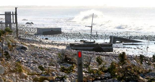
Above: Irene swept away so much sand
that beach trailers’ homesite tight tanks were exposed. Photo | EverythingWestport.com ©
2012 All rights reserved. In 2008/2009, the Army Corp
of Engineers dredged the entrance into the Westport Harbor, depositing the
sand on Boater’s Beach, heading east. The effort created a berm 3 feet high
and 2000 feet long from the dune edge to the highwater mark on the beach. The beach nourishment effort
was quickly washed away in just a few months by tidal flow and high tides. So much for beach nourishment;
it isn’t going to work on this stretch of Cherry & Webb Beach, and is
sketchy for East Beach at best.
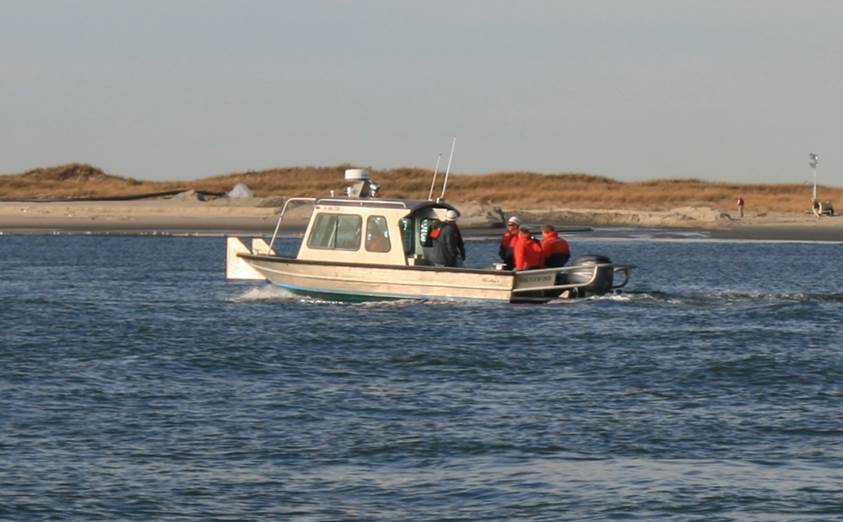
Above: The Westport harbormaster takes
state officials on a tour of the Westport River dredging project. In the
background is the 2000-foot long sand berm that was created from the harbor
entrance’s dredging material. Unfortunately, the replenishment/nourishment
material was washed away by wave action in less than two months. Photo
| EverythingWestport.com © 2012 All rights reserved.
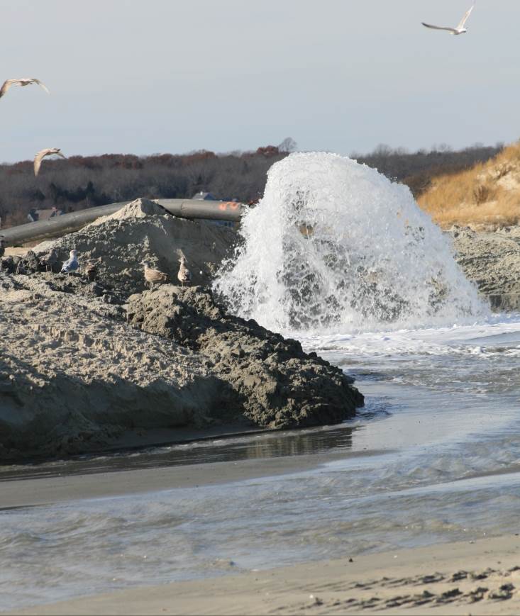
Above: Sand and water from the barge’s pump deposited material onto
Cherry & Webb Beach down by Boater’s Beach. Photo | EverythingWestport.com ©
2012 All rights reserved.
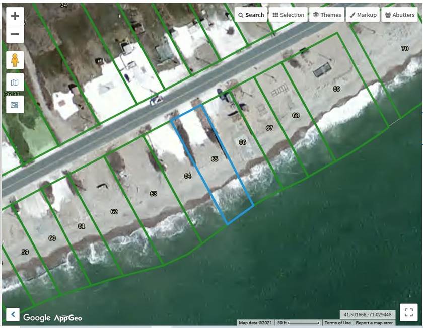
Above: This MAPGEO image of a portion East
Beach Road shows how much of the East Beach south trailer lots have been lost
to wave action.
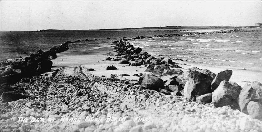
Above: This photo of the rock-lined sandbar
leading to Gooseberry Island is prior to the construction of the causeway in
1924. The rocks helped travelers in
vehicles (wagons?) reach the island at low tide. Photo courtesy of the Westport
Historical Society - - - - - End - - - - - © 2021 Community Events of
Westport All rights reserved. EverythingWestport.com |