Southwind clears the Harbor Channel
By Jon Alden
Everything
Westport
Friday,
December 28, 2007
View a photo album of all
photos | Dial-up speed | Broadband/DSL speed |
Click on any image
below to enlarge
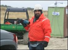
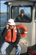
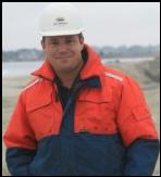 The call came at 12:10 p.m.,
December 20. “We’re going home,” Devon “Hollywood” Carlock
(left) said. The handsome, Southwind Construction Field Superintendent just received word
that the Army Corps of Engineers had signed off on the Westport Harbor dredging
project. He and the remaining two crew members could now cut up the pipe, load
the flat beds with equipment and materials, and head home. The barges and
heavier work boats would be hauled out of the water and transported back after
the holidays.
The call came at 12:10 p.m.,
December 20. “We’re going home,” Devon “Hollywood” Carlock
(left) said. The handsome, Southwind Construction Field Superintendent just received word
that the Army Corps of Engineers had signed off on the Westport Harbor dredging
project. He and the remaining two crew members could now cut up the pipe, load
the flat beds with equipment and materials, and head home. The barges and
heavier work boats would be hauled out of the water and transported back after
the holidays.
The Corps
had been out the previous day in a survey boat, taking soundings. The new channel
passed inspection.
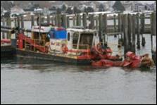
The work
wasn’t always easy. “The moon tides were just kicking our butt,” lamented Mike
“Twink” Will (below left), the
burley Southwind Construction senior Field
Superintendent. “We put the pipe straight out there at slack tide and started
pumping, but the outgoing tide bowed the pipeline, broke the 1000 lb anchors
free, and snapped the line like a twig. Twink, as his friends call him, had to
fight high, rapidly moving, full moon tides for most of the first two weeks.
 Twink
tames the troubled waters!
Twink
tames the troubled waters!
In the end,
Twink rerouted the 12” diameter, 1” thick pipe northward around boater’s beach,
across the salt marsh flats and Bailey’s Flat, that then looped southwest to
begin dredging down and out of the channel rather than up and in. This new course
decreased the threat from the treacherous current of the outbound full moon
tides. As Twink explained it; “being the stubborn Dutchman that I am, after a
bunch of line breaks I came to realize I had to do something different!”
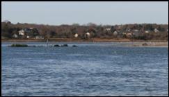
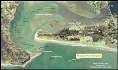
It’s easy
to see why the British refused to enter the channel during the Revolutionary
War. The tidal currents that can push boats dangerously close to the rocky Nubble and the old stone groin further exacerbate the
narrowness and sharp turns of the channel’s entrance. “This project will widen
the navigable channel to 200’ feet wide and 10’ deep at mean tide,” Richie Earle said. “During the 60’s and 70’s channel
shoaling forced most of the large lobster and fishing boats to leave and find
port in Fall River or New Bedford.”
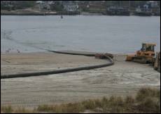


Above, left to right: It took a bulldozer and other heavy
equipment to keep the pipeline from being washed out to sea. (2)
This scene was repeated over and over as the broken line had to be repaired by
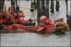
the working barge. (3) The culprit;
a full moon created rapidly flowing tide flows. (4) The fusing, or “welding” machine as it is called, joins evenly-cut
pipe ends together under 2000 psi pressure and high
temperatures from a “heat strap”, forming a stronger bond than the pipe itself.
(5) The line was finally rerouted to
the north, turning south west down and out of the channel to minimize current
interference.
 Westport Harbor’s first recorded
dredging occurred in 1893 and was conducted by the Corps. Little is known about
the project, but it’s suspected the sand ended up as a Horseneck Point dune. A
sequence of River and Harbor Acts starting in June 18, 1878 resulted in the
construction of a single timber-crib “sand catch” jetty that was eventually
replaced by a 150-foot long rubble mound in 1891; both were designed to reduce
shoaling (sand build-up) in the inlet.
Total cost of the projects - $2000! The Department of War extended the
jetty by 200’ in the early 1920’s. “At high tide the jetty was awash,” said Richie Earle, Westport’s affable Harbormaster. “Sadly, the
’38 hurricane knocked it over, rendering it useless.” Remnants of the jetty can
still be seen today (left).
Westport Harbor’s first recorded
dredging occurred in 1893 and was conducted by the Corps. Little is known about
the project, but it’s suspected the sand ended up as a Horseneck Point dune. A
sequence of River and Harbor Acts starting in June 18, 1878 resulted in the
construction of a single timber-crib “sand catch” jetty that was eventually
replaced by a 150-foot long rubble mound in 1891; both were designed to reduce
shoaling (sand build-up) in the inlet.
Total cost of the projects - $2000! The Department of War extended the
jetty by 200’ in the early 1920’s. “At high tide the jetty was awash,” said Richie Earle, Westport’s affable Harbormaster. “Sadly, the
’38 hurricane knocked it over, rendering it useless.” Remnants of the jetty can
still be seen today (left).
In the
1950’s the channel was dredged by the state; the sand was used to create an
astonishingly out-of-place beach at the Spindle Rock Yacht Club.
The Corps
is paying 80% of the dredging’s projected cost of
over $760,000, with the state picking up 15% and the town 5%. “Westport
instituted a $1 per foot boat surcharge over 3 years,” Mr. Earle said. “We
raised $81,000 that was used for initial research and feasibility studies, and
our ultimate contribution to the project. The total cost of this entire effort
will be close to a million dollars.”
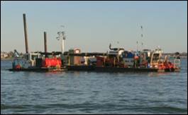
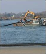
Above, left to right: (1)
The pumping dredge with the work boat, the Betty Lou,
along side. The “spuds”, or the two metal columns at
back end of the dredge are alternately hydraulically-raised and lowered to
allow the dredge to “walk” along the desired sand-removal path. (2)
The dredge employs a cutter, or “basket claw” to churn up the bottom sand. (3) The Anaconda-like pipeline snakes
away on Horseneck Point. (4) Every
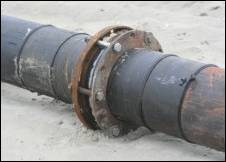
250’ to 500’, or so, the pipe was flanged to facilitate movement or repair. The
“welded”, beaded seams are clearly seen in this photo.
Southwind
Construction in Evansville, IN won the bid as dredging contractor.
The heart
of Southwind’s hydraulic pumping dredge is a 400 hp Caterpillar diesel capable
of pumping 5-6000 gallons of water per minute (a sand/water mix is less)
through 7000’ of 12” pipe. “This is not your garden-variety, house sump pump,”
Twink said. The line is comprised of polypropylene sections “fused or welded”
together, on-site, under heat and pressure to form a continuous line that
eventually went to 4700’. “The pipe we used came from the same job where we got
the equipment for this project. Sections of that pipe were internally worn thin
from the abrasion of sand and rock, and those areas failed under the severe
tide changes,” Twink explained.

Left to right: Johnny from Florida, Stan from
Tennessee, Phil from Indiana, and Hollywood with two crew members in the
staging area..
The crew of
12 worked in two six-man, 12-hour shifts for most of the project - sun by day,
hi-powered lights by night. “Equipment failures are expected,” Twink said, “but
unexpected severe weather can cause personnel breakdowns. Our crew wonders why
they have to work under these conditions.” They were tested by Westport’s first
winter storm. “Our line broke once, and we had to suspend operations on Sunday
(December 16) due to high winds and a two foot storm surge,” Hollywood said.
“But the dredge handled it OK.”
Pumping is
near continuous, whether it’s a sand/water mix or just water. “It’s easier and
structurally safer to move the pipeline with water in it, just like winding a
full water house on a house reel is easier and prevents kinks,” said Twink.
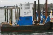
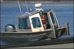
Left to right: the two-section working barge; the
working boat Miss Leanne, the multi-purpose Betty Lou; and the Southwind dredge and cutter boom.
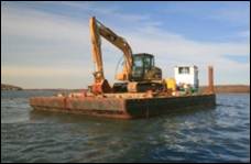
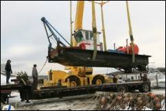
Southwind
trucked up from Louisiana a major portion of their equipment: A 50,000 lb
working barge in two sections; the dredge and cutter boom; the working boat
Betty Lou; the working winch and fuel boat Miss Leanne; and an aluminum
transport/push boat. Also, they brought a bulldozer, an industrial-sized fork
lift, and a back hoe - all Caterpillar-made. There were generators, fusing
equipment, night lighting, 1000 lb anchors and buoys, 7000’ of 12”
polypropylene pipe in 50’ sections, and assorted tools and transportation
vehicles. The working boats behaved more
like small tugs in moving and stabilizing the heavy dredge and barge in the
swift currents of Westport Harbor. The staging area looked like a miniature
ship building yard. A huge crane was brought in to launch the barge and dredge.
Read
the story about Southwind’s arrival.
“The
equipment we brought up out of Louisiana is for smaller dredging projects,”
Twink said. “Maritime law says dredging operations must give way to commercial
and pleasure craft. In a channel as small as Westport Harbor, our larger stuff
would have blocked the channel. It would have done the job a whole lot faster,
but we couldn’t keep moving our larger dredge.” Twink frowned. “The smaller
pipe that came with this equipment was well worn, and contributed to the
breakage caused by the moon tides.”
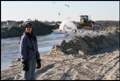
 Federal regulations require dredging projects to occur from October 15
to January 15 to
protect spawning fish, not exactly the greatest time to be working in New
England waters. The picture to the left
demonstrates, however, the importance of this regulation as the Southwind dredge and working boats are within feet of the
fragile, protected Acoaxet Herring Run.
Federal regulations require dredging projects to occur from October 15
to January 15 to
protect spawning fish, not exactly the greatest time to be working in New
England waters. The picture to the left
demonstrates, however, the importance of this regulation as the Southwind dredge and working boats are within feet of the
fragile, protected Acoaxet Herring Run.
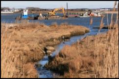
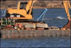
The working
dredge has a large cutter, or “basket-claw” which spins in the sand, churning
it up. The resulting sandy soup is vacuumed into a pipe positioned behind the
cutter, pumped through the line, and eventually deposited on the beach in a
mountainous spray of sand and water. Any fish in the area, especially smaller
ones, would be swept up and hurled on the beach, making for happy gulls, and very
unhappy US Fish and Wildlife Service personnel. Read how they
are protecting our spawning species.
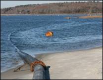
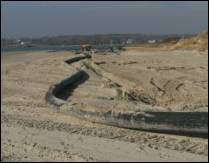
A deflector
shield at the pipeline’s end keeps beach erosion to a minimum, allowing the
water to separate from the sand, and run back into the sea. The remaining sand is
bulldozed aside, and eventually smoothed into a low, long mound; its width
started at the dune line and worked 30’ to 40’ toward the high-tide mark.
Approximately 23,000 cubic yards of sand was removed from the channel.
The lengthy permit process had to overcome
many financial, political and environmental issues.
The nasty
weather and water conditions Southwind faced paled in
comparison to the odyssey Westport had in seeking approval for Federal
navigation improvements to the Westport Harbor. “Between the town, state and
federal authorities we had to pull between 50 and 75 permits,” Mr. Earle
explained. “There were Chapter 61, water quality certificates, Order of
Conditions, removed material evaluation; the list went on and on,” Mr. Earle
said. “The U.S. Fish and Wildlife Service had concerns that the Town of Westport
wasn’t doing enough to protect endangered coastal nesting birds.” The State’s Division of Waterways and Wetlands
also emerged as a secondary player in seeking approval for the dredging. “Major responsibilities of the Office of
Waterways include the design and construction of waterway improvements, flood
control facilities, and shore protection projects as well as the dredging of waterways,”
said Kevin Mooney, the design and construction engineer for the state Office of
Waterways. “The state has control over tidal rivers,” said Mr. Earle. ”It may
be a federal project but the state gets their oar into the water. Kevin Mooney
was a great resource for the Town of Westport.”
A major
issue was avoided as the material to be removed from the channel exactly
matched the composition and grain size of the sand on Horseneck Point.
“Otherwise,” Mr. Earle said, “we would have had to transport the material to a
federally-approved, off-shore site which would have added considerable expense
to the project.”
 “The beach nourishing material to be
deposited on Horseneck Point could attract the endangered least tern,” said
Gina Purtell, Director, Allens
Pond Wildlife Sanctuary (left).
“Raising the beach height by four feet may reduce the birds’ fear of a
“wash-over” of their nesting sites. Moreover, the dangers posed by man and
predator could cause their breeding efforts to fail.” She continued; “It might
be better not to change the beach at all, allowing the least terns to remain
where they are. In addition, each year we also struggle with the piping
plover,” Ms. Purtell said. The threatened New England
Puritan Tiger Beetle was also reported to have been sighted in the Horseneck
Point area.
“The beach nourishing material to be
deposited on Horseneck Point could attract the endangered least tern,” said
Gina Purtell, Director, Allens
Pond Wildlife Sanctuary (left).
“Raising the beach height by four feet may reduce the birds’ fear of a
“wash-over” of their nesting sites. Moreover, the dangers posed by man and
predator could cause their breeding efforts to fail.” She continued; “It might
be better not to change the beach at all, allowing the least terns to remain
where they are. In addition, each year we also struggle with the piping
plover,” Ms. Purtell said. The threatened New England
Puritan Tiger Beetle was also reported to have been sighted in the Horseneck
Point area.
In the end,
the Town of Westport awarded a bid contract to the Allens Pond Sanctuary for a
period of three years to monitor the effects the beach nourishment program may
have on the three threatened species.
Meanwhile,
the quest for Federal Navigational improvements, which initially started in
1990, was encountering obstacles. “We had to work hard,” Mr. Earle said, “to keep the project alive. Channel bottom soundings
occurred in 1998 and 1999, and we funded feasibility studies to move the
process along.” Increasing numbers of boat groundings in the channel were also
a motivating factor. “The constant groundings in the channel were driving the
Coast Guard and me crazy,” Mr. Earle said. “Our fishermen have suffered the
most, not only from damage to their vessels, but waiting for the tides to get
in and out of the harbor,” he said. Delays mean time, and time means money. ”It’s
also quite expensive to be constantly relocating mooring fields whenever the
channel shifts,” Mr. Earle said.
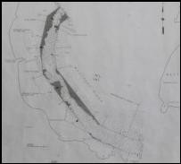 Hydrographic
surveys were conducted by the Corps in June 2001. A hydrographic survey is the
process of gathering information, including soundings, about navigable waters
for the purposes of safe navigation of vessels. The darker gray areas in the
sounding survey (left) signify sand
to be removed in the channel.
Hydrographic
surveys were conducted by the Corps in June 2001. A hydrographic survey is the
process of gathering information, including soundings, about navigable waters
for the purposes of safe navigation of vessels. The darker gray areas in the
sounding survey (left) signify sand
to be removed in the channel.
Then, in
2004, the town received approval for the project subject to funding. “The
Town’s dredging application finally met the Corps cost/benefit ration of 2.3 to
1,” said Dredging Committee Chairman Richie Earle.
“In principle we got the project approved,” “but we didn’t get the money.”
Then hurricane
Katrina hit the Gulf Coast on August 29, 2005. Much of the Army Corps of
Engineers resources were deployed to Louisiana, and the harbor dredging program
was put on a back burner. But in 2006 the political make-up of Congress changed
and, with much pushing and the great assistance of Barney Frank’s office,
federal funding was finally obtained. “We’re got the go-ahead,” Richie Earle said, crediting U.S Representative Barney
Frank for his efforts “bird-dogging” the town through the federal labyrinth of
funding. “Kerry’s and Kennedy’s offices were also very supportive,” Mr. Earle
said.
There were only a few glitches in the
completion of the dredging.
“We had to
re-dredge the southeastern edge of the channel because of the steep slope cut
in that area,” Hollywood said. “By the time we completed the project, that
severe incline allowed somewhere between 2-3000 cubic yards of sand to roll back
into the channel. We cut back another 50’ to lessen the sand drift”. The Corps
requires a 1 to 3 slope. Also, the dredging crew at one point ran into shale
and hardpan at 9’, and a decision was made by the Corps to relocate a portion
of the channel as a workaround.
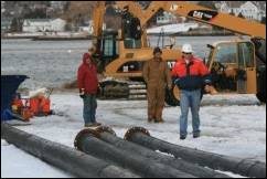
The Town of
Westport and Southwind Construction received a site
visit on November 28 from the top officials overseeing the harbor channel
project. US Army Corps of Engineers (Corps)
New England District officials COL Curtis L. Thalken
- Commander and District Engineer, John R. Kennelly,
III - Chief, Planning Branch, and Maurice Beaudoin -
Resident Engineer in the New Bedford Office, along with others joined with
Garth Patterson of Barney Frank’s office to inspect the progress of the dredging.
They were captained by Richie Earle in the Westport
Harbormaster’s boat, and by Hollywood in the firm’s transport boat out onto the
cold, windy harbor for an up-close, personal look at the dredging progress.
Also
present were the Westport Town Manager, Mike Coughlin, and several other New
England District Corps personnel including Mike Tuttle, Project Manager in the
Concord Office, and Tim Rezendes, Resident Engineer
in the New Bedford office.
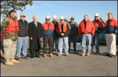
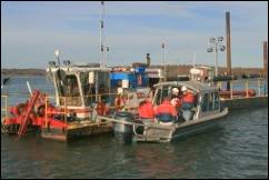
Above, left to right: (1) (from left to right) Corps New
England District official COL Curtis L. Thalken -
Commander and District Engineer; Westport Harbormaster, Richie
Earle; Westport Town Manager, Mike Coughlin; Tim Rezendes,
Corps Resident Engineer in the New Bedford office; John R. Kennelly,
III, Corps Chief, Planning Branch; Maurice Beaudoin, Corps
Resident Engineer in the New Bedford Office; Mike “Twink” Will, Southwind Construction senior Field Superintendent; Mike
Tuttle, Corps Project Manager in the Concord Office; Devon “Hollywood” Carlock, Southwind Construction
senior Field Superintendent; and Garth Patterson of U.S. Representative Barney
Frank’s office. (2) Hollywood takes
the Colonel and Garth Patterson, among others, for a tour of the Dredge. (3) The site inspection also included a sightsee of the Horseneck Point nourishment with the sand
removed from the channel. (4) Richie Earle takes Corps Resident Engineer in Charge “Mo” Beaudoin for a channel excursion in the Harbormaster’s boat.
“Westport
Harbor is now a federally-designated channel,” Mr. Earle said. “It is incumbent
on the Federal Government to keep this waterway navigable, which is of huge
benefit to the Town of Westport.” Mr. Earle estimates that the dredging will be
good for another 15 to 20 years, barring any hurricane doings. “We can dredge
the channel of encroaching sand,” Mr. Earle said, “but strong storms will put
it where they want to.”
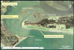 Part of the dredging project also
facilitated the relocation of the channel, as it exits Westport Harbor, to the
left of Half Mile Rock, eliminating the very dangerous turning conditions that
have resulted in capsized boats and some fatalities during very choppy
conditions. The Coast Guard will install navigation aids to mark the new route.
Part of the dredging project also
facilitated the relocation of the channel, as it exits Westport Harbor, to the
left of Half Mile Rock, eliminating the very dangerous turning conditions that
have resulted in capsized boats and some fatalities during very choppy
conditions. The Coast Guard will install navigation aids to mark the new route.
“The sand
used for nourishing Horseneck Point was deposited only on Town-owned land,” Mr.
Earle said, “and extends from the dune line to just below the high tide
line.”
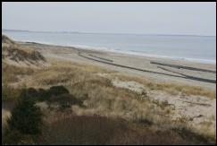
Those
walking towards the end of Horseneck Point will see a new long, low mound of
beach sand extending for about 2000’. Deeply dug scars from the heavy equipment
will eventually be smoothed by wind and water, and the beach’s natural contours
will return with the help of winter storms and moon tides. Mother Nature,
however, has the last say in the sand’s ultimate disposition.
True to Mr.
Earle’s predictions, the dredging crews also found and retrieved some old
moorings (below, left), long since
abandoned. Tripps Boatyard was happy to get them. It’s
plausible those old moorings could have done a better job than the 1000 lb iron
anchors (below right) in securing
the pipeline!

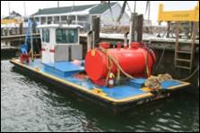
The work
boat “Betty Lou” (above, center) got
to go home before Christmas. “She sprang a leak,” said Hollywood. “We need to
send her back for repairs. The rest of the crew already went home in time for
the holidays.” The three remaining team members leave on Friday. “And I’m ready,”
Hollywood said!
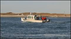
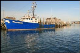 Dredging of the channel leading into
the harbor was completed in late December, but most recreational boaters will
have to wait until late spring 2008 to experience the difference. We may not
get our large commercial fishermen back, but we will make it more comfortable
for boats like the Broadbill (left)
and the Alice T.
Dredging of the channel leading into
the harbor was completed in late December, but most recreational boaters will
have to wait until late spring 2008 to experience the difference. We may not
get our large commercial fishermen back, but we will make it more comfortable
for boats like the Broadbill (left)
and the Alice T.
Want to read more
about Westport Harbor restoration projects? View photos of Town Pier restoration http://www.cwhitemarine.com/westport.htm
- - - - - - End - - - - - -
Community Events of Westport ©
2007, 2008 All
rights reserved.